Aerial Photography and Visualisation for Built Heritage - PhD Portfolio by Kieran Baxter
Home Portfolio Showreel Publications Map Blog Contact

Saturday, 20 July 2013

High & Low Exhibition Open at Falkland Centre for Stewardship

An exhibition of my aerial photographs - including images from a kite platfrom, light aircraft, and computer generated orthographic views by Susie Green - opened at Falkland Estate on Tuesday with launch event and presentation. I was please to see a good number of attendees for what was an enjoyable evening with lots of good questions and discussion.

Pairs of aerial photographs are displayed in the converted stables.
The exhibition itself is set up in the Stables where it will remain until mid August. The old horse booths create a great space where images can be grouped into pairings like these:

High & low altitude vertical photographs of White Caterthun showing subtle enclosure remains.
This example shows two near-vertical views of White Caterthun hill fort in Angus - one from high altitude and the other taken from a camera suspended from a kite. The lower view (on the right) shows the remains of a circular enclosure, seemingly underlying the main rampart, which is made more visible in the melting snow.

The range of images includes ortho-rectified views by Susie Green.
As well as a series of oblique views from high and low altitude the exhibition includes orthographic renders of Susie Green's very high resolution computer models of White and Brown Caterthun generated from structure from motion photogrammetry (see Susie's website here).


The exhibition marks the end of an image gathering stage of a pilot project exploring the characteristics of different aerial photography platforms, methods and approaches. the next stage is to take this imagery and bring it forward into more cinematic and interpretive outcomes, which further tell the story of these fantastic monuments. This animated test of Maiden Castle in the Lomond Hills gives a sense of the potential for this kind of imagery.

The Falkirk Wheel and Arria Sculpture, Cumbernauld

On a recent trip to Glasgow I stopped off at a couple more modern sites to get some kite photos. The Falkirk Wheel - with it's the circular basin, bold architecture and impressive engineering - makes a great subject for the aerial view.

The Falkirk Wheel with the Ochill hills in the distance.
The worlds only rotating canal boat lift was opened in 2002 and connects the Firth and Clyde Canal with the Union Canal. When it is not in use for canal traffic short boat trips take visitors up and down the lift.

An elevated aqueduct carries boats to the top of the lift.
This shot gives an unusual angle on the familiar Arria sculpture which overlooks the busy M80 near Cumbernauld. More about the story behind the sculpture is on the website (here) of it's creator Andy Scott.

The Arria sculpture by Andy Scott stands near Cumbernauld.

Sunday, 30 June 2013

The World Wide KAP Project Banner Comes to Dundee

The World Wide KAP Community Project was the idea of Argentinian kite aerial photographer Ramiro Priegue who, in 2009, sent the WWCP banner on its journey around the world. Each participant takes some kite photographs featuring the banner, signs it and passes it on. You can plot the banners intrepid journey using the map and gallery at: wwkp.kiteaerialphoto.org. I was lucky enough to be one of the KAPers to take care of the banner as it passed through Scotland this year.

The Law Hill, Monument and city of Dundee with the WWKP banner.
This first kite aerial photograph with the banner was taken above Law Hill, which dominates my hometown of Dundee. Incidentally, the two red and blue striped tower blocks on the right hand side of the frame were demolished just 11 days after this shot was taken (video here). This makes the photograph already out of date but all the more unrepeatable! A rectangular Iron Age hill fort once spanned the entire summit of the hill and the ramparts are still visible to the left of frame (site record here), although the near end has been destroyed during the building of the war memorial and viewing platform.

Passing between KAPers, the banner has already circumnavigated the globe.
Another favorite local KAP spot which I felt was a must for the banner was Broughty Ferry Castle. Seen here in evening light with Broughty Beach and the mouth of the Tay Estuary behind, the castle's complex shape makes it an interesting subject from low altitude.

Broughty Ferry Castle with the WWKP banner, kite aerial photograph.
Compared to the blustery Law Hill, the promontory at Broughty Castle offered clean winds with an chance to experiment with camera angles a little more. A wide angle lens makes the most of the converging vertical lines in this shot of the castle entrance.

A wide angle near-vertical shot of the castle and banner.
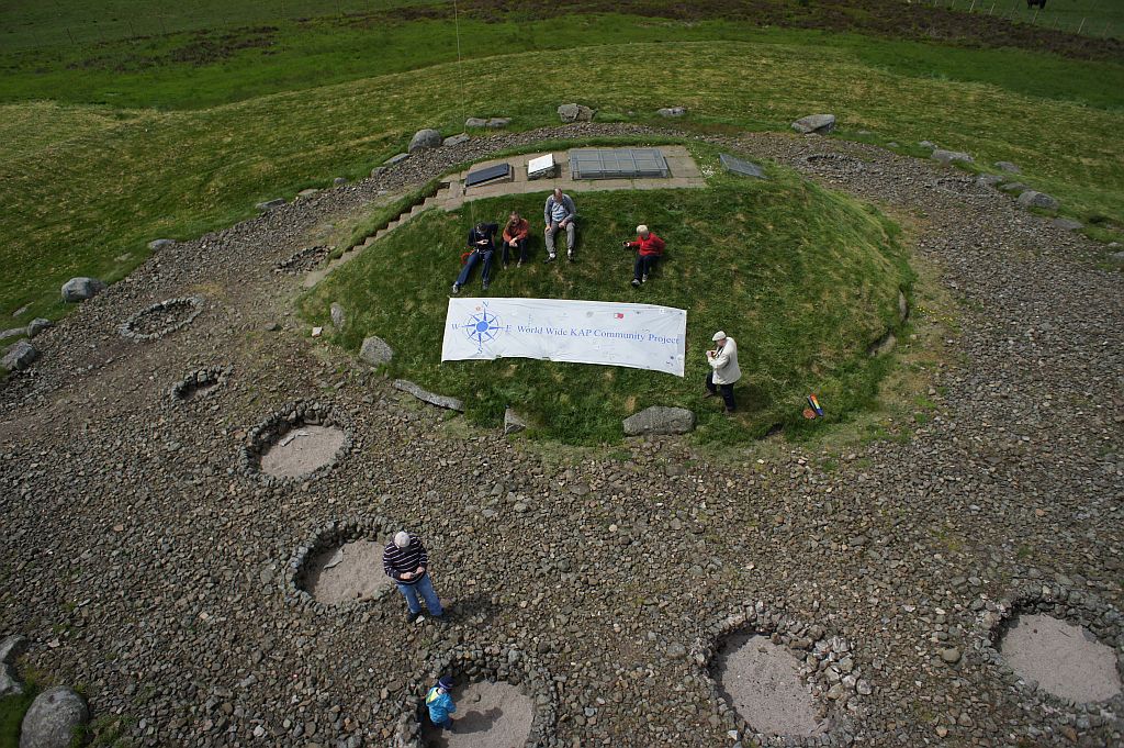
The project aims to bring KAPers together as a community and one of the ways it does this is by providing a good excuse to meet up in order to pass the banner on. I collected the banner from James Gentles at Cairnpapple, a neolithic ritual complex in Westlothian, where we were joined by fellow KAPers Simon Harbord, Sue Storey, John and Cade Wells (and trainee Tom), all of whom can be found listed on the West Lothian Archaeology Group pages here.

The handover at Cairnpapple, kite aerial photograph by James Gentles © 2013.
James took this shot of all of us with the banner using a remote control rig. This was the first time I had visited Cairpapple, which has special significance both archaeologically and as a focus point for KAP in the Westlothian area. I was last to arrive at the meeting and, as I approached the site, snapped this view with the banner visible and all the kites already in the air.

The group of KAPers flying with the WWKP banner at Cairnpapple.
The banner is always on the move and with it being nearly time for me to pass it on to the next participant, Robert Insall, I found a spot to add my logo. The project has generated a fantastic collection of stories which will hopefully continue to accumulate for many more years as the banner wings its way across the globe.

Joining the many distinguished and multinational signatures on the banner.
You can see the current location of the banner along with past and future participants at: wwkp.kiteaerialphoto.org

Tuesday, 25 June 2013

High & Low - An upcoming exhibition and talk on aerial explorations of the hill forts of Fife and Angus

You are invited to attend an exhibition by Kieran Baxter as part of a PhD investigation into the creative application of aerial photography & computer generated imagery for heritage & archaeological storytelling.


This showcase features unique views of hill forts spanning from East Lomond hill above Falkland in Fife, to the Caterthuns nearby Bechin in Angus. Often passed-by but sometimes difficult to appreciate from the ground, these prehistoric banked enclosures are intriguing because of their form and longevity. This exploration looks at how our appreciation of these sites and landscapes is mediated through different types of image. Using high and low altitude aerial photography along with state-of-the-art digital imaging techniques in collaboration with Susie Green from University College London, this presentation of imagery ranges from the archaeological to the cinematic.


Free launch event and talk - Tuesday 16th July, 7pm. See a presentation of images and computer generated animation with a brief explanation of the approach and techniques used to capture and process them. All welcome, refreshments provided.

Free exhibition - Throughout the weeks beginning 15th July, 29th July & 5th August 9am-5pm Monday to Friday. Please phone the Centre for Stewardship on 01337 858838 to check weekend opening hours. The exhibition is held in the Horse Stalls.


The event and exhibition will be held at The Stables, Centre for Stewardship, Falkland Estate, Falkland, Fife, KY15 7AF. Any questions? Please feel free to contact me. The exhibition also has its own page at topofly.com/highandlow where you can find more updates and info.

Friday, 14 June 2013

Evening Light at Evelick Hill Fort

After my previous reccy of this location in the Sidlaw hills (post here) I returned to of Evelick hill fort with low evening light to bring out the topography.

Evelick hill fort and the Tay Estuary, kite aerial photograph
The shadows show the earthwork ramparts on one side and the steep natural defenses on the other. You can even make out the shadow of the hilltop on the farmland below - a reflection of the way in which these Iron Age monuments tend to visually dominate particular areas of arable land.


Here is the site on Google Maps, from where you can make out more of the embankments and enclosures which make up the fort. More details and high aerial photographs can be found on the RCAHMS site record page here.

Wednesday, 29 May 2013

Jarlshof Broch KAP Featured in Antiquity Photo Competition

My kite aerial photograph of the Iron Age broch at Jarlshof is one of two winners of the photography competition in the current issue of Antiquity: a quarterly review of world archaeology.

Jarlhof broch from above features in this quarter's Antiquity photo competition

For this vertical shot the camera was positioned directly above one corner of the relatively modern Laird's house to reveal the half circle of the broch remains, which have been partially lost to coastal erosion. If you haven't quite gotten hold of your copy of Antiquity yet, here is the image that was published.

The broch is disguised from the ground by the remains of later structures
From ground level the broch architecture is confused by later a wheelhouse, cells within the thick walls as well and the later Laird's house which cuts through the wall. From above the meticulous engineering and drystone craftspersonship is immediately apparent. This shot was made possible with the assistance of Sumburgh Airport Air Traffic Control who oversaw kite flying so close to a busy airport. The property is in the care of Historic Scotland who also kindly accommodated for the project.

More images and the story behind my interpretive visualization of the spectacular site of Jarlshof are compiled on this page: topofly.com/jarlshof

Wednesday, 15 May 2013

East Lomond Hill Fort, Glory and Shadow

An early start and a short hike saw me on top of East Lomond Hill just as the sun began to rise, ready to get some kite aerial shots. Approaching the distinctive profile of the hill - which can be seen right across Fife and a good distance beyond - I could see wisps of cloud forming off of the hilltop, visible in this photo.

Approaching East Lomond Hill on foot at dawn
Once the kite and camera were in the air and I was surprised to see this circular "glory" created by the sunlight hitting the low cloud (see this Wikipedia article on the optical effect). This one was particularly striking as the camera rig is too small to cast a shadow on the unbroken circle.

A 'glory' reflected in the low cloud with kite line to the right of frame
The cloud soon cleared to reveal a view looking down upon the earthwork remains of the hill fort (RCAHMS site record here) with West Lomond hill behind, still shrouded in cloud. Also visible in this shot is is the enclosed hillock Maiden Castle (site record here) rising behind the trees (above and to the left of the near summit of East Lomond).

East Lomond hill fort kite aerial photograph
In not-so-perfect conditions this brief window of sunlight picked out the relief and shadow of the site nicely, leaving dramatic skies in the background. I like how the distant shadow provides extra information about the topography, rather like in this high altitude shot of the same site which I took back in March.

East Lomond hill fort photographed from higher altitude
In both images the shadow defines the characteristic profile of the hill, which largely disappears otherwise when seen from above. While the prehistoric earthwork embankments which circle the summit are visible in the low light, I think these images have more to say about the way in which the enclosure dominates it's surroundings.

Good views making up for cold hands
Shooting out of the open window of a fast moving Cessna 172 offers a fleeting (and breezy) vista of the land below. This portrait was taken by photographer Kieran Duncan who assisted on that aerial photography excursion and, it must be said, bore the brunt of the icy cold air flow.