Aerial Photography and Visualisation for Built Heritage - PhD Portfolio by Kieran Baxter
Home Portfolio Showreel Publications Map Blog Contact

Saturday, 24 March 2012

Carlungie Souterrain KAP


Carlungie souterrain is one of three of these Iron Age cellars near to Dundee which have served as a bit of a testing ground for my equipment and techniques for low altitude aerial photography and photogrammetry. These images were taken using a kite during mid afternoon sunlight to show up the paved floor.

The smaller snaking passageway would have lead from space where the residents lived to the large cellar space which would have been roofed, creating cool and dry conditions. From above the remains form an interesting sprawling pattern which shows the vast extent of the storage space. The entrance passage in contrast is very narrow and would only have been accessible by crawling.


I will use this sequence to generate a 3D model which I can use to experiment with ways of viewing the site. The RCAHMS site record can be found here.

Tuesday, 13 March 2012

Falkland KAP Meet


Some photographs from Falkland in Fife where I met two accomplished kite photographers James Gentles and Simon Harbord. After some discussion on gear and technique as we waited for the wind to pick up we finally did some KAP over the royal palace and village in the late afternoon.


Trying to get clear of the ground are James's Saltire Dopero, Simon's yellow Delta and my Fled in the foreground. Always a pleasure to meet with like minded KAPers!

Monday, 12 March 2012

Kilmartin Glen Visit

I recently visited Kilmartin Glen in Argyll on the Scottish west coast to photograph the prehistoric monuments which line the valley for a commission for Historic Scotland. I was treated to an afternoon of good wind when I got material for most of the sites of interest - I won't post the best ones here yet as it is a commission and an ongoing project.


These standing stones at Ballymeanoch are associated with a small burial cairn visible to the right, and a circular henge which is out of frame here. Aerial photography aims to show the relationship between the monuments with the evening light bringing out the relief, necessary for the henge which is quite a subtle earth form.


Dunnadd is a defensive hill settlement which remains in ruins at the entrance to the glen. The carving of a footprint is famously considered to be the spot where ancient kings were inaugurated. The carving itself was covered by the replica seen today in 1978 in an effort to protect against erosion. It was lifted to check on the state of the original stone in 2009, as described in this article.


Kite photography here again aims tie the different components of the site together. In the frame below part of the citadel wall is visible on the summit on the left just above the inauguration stone replica. Further down the slope and out of frame are outer walls and entrance to the settlement as well as a small well. The vast flat land which leads to the sea, visible in the background, would have given the hill it's strategic advantage. Many of the surrounding hills also have forts built on them at it is thought that sightings could have been relayed between these outposts.

The advantage of settling on a site with an elevated viewpoint to get a better lay of the land seems not dissimilar to my own endeavors. The main issue I find photographing hill sites like this one is that they tend to flatten out when viewed from above, again raising the need for oblique evening or morning light. Unfortunately during the sunrise pictured above there was not a breath of wind!


This photograph of Nether Largie standing stones was taken during a full moon with a long exposure and a torch, shone in such a way to reveal the cup marks carved into the central stone. The density of ancient sites along the glen give it a surreal atmosphere. I look forward to returning to complete the project work.

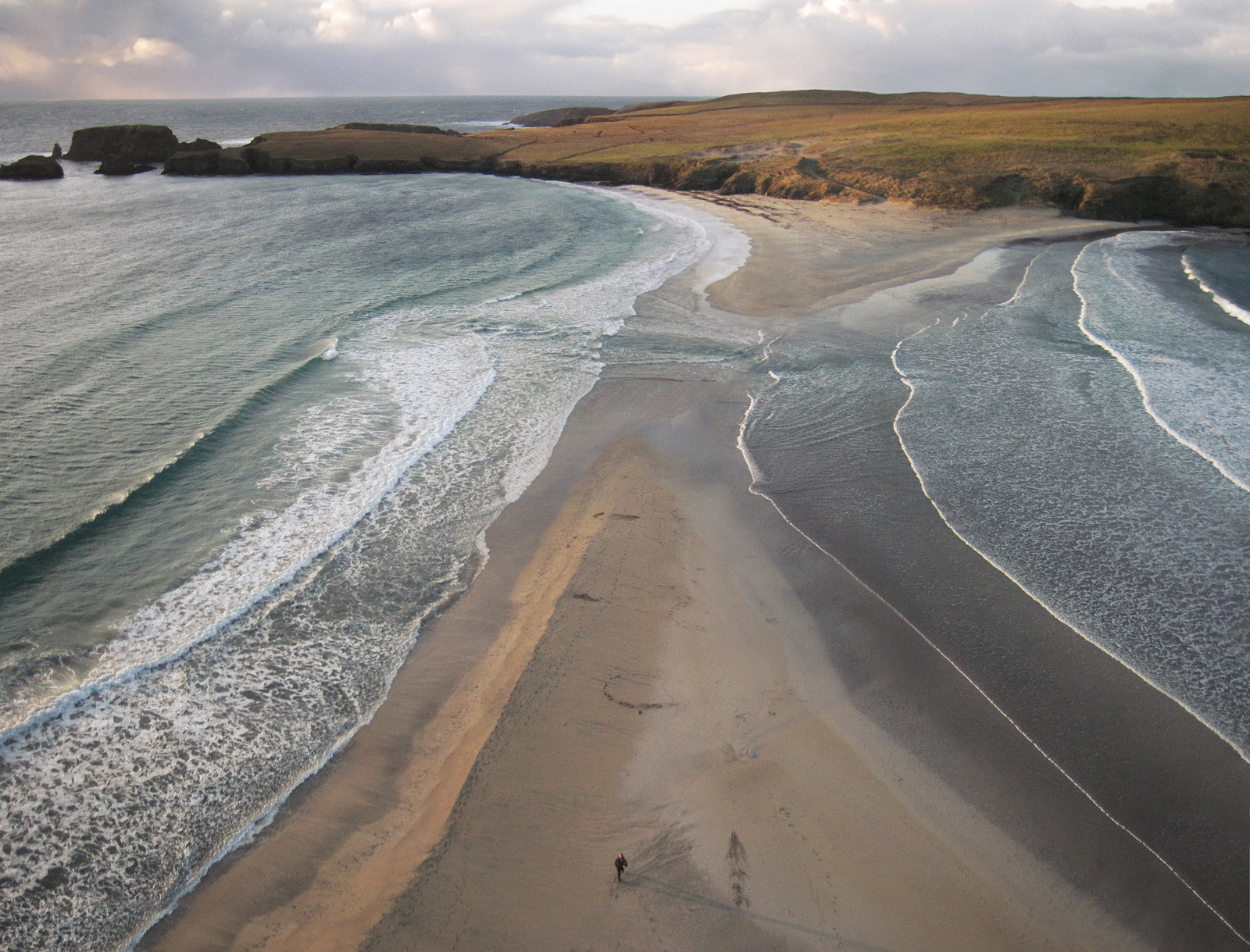
Capturing Context at St Ninain's Isle

These photographs of St Ninian's Isle, taken on my field trip to Shetland in December, give a striking example of the illustrative qualities of the low altitude aerial view. the island is connected to the south mainland by a sand tombolo, seen here swamped by the high tide. Archaeological finds here date back to Neolothic times and on the far right hand edge of the wide photograph the remains of a chapel are visible. In 1958 a horde of silver artifacts were discovered here, thought to have been buried in a hurry around 800 AD.


From above the scale of the sand bar an the force of the ocean become obvious making the figure look rather vulnerable. The dramatic conditions give a sense of the character of the place. It's isolation has played an important part in it's history providing safe haven at some times while ultimately leading to it's abandonment in 1796. In the view from above the limits of the small island are evident in the background of the sweep of the tombolo, a combination which is illustrated well from a low altitude angle.


I've left the kite line in this tighter angle shot, that's me trying to keep my feet dry with one eye on the kite!

More about the history of the island can be found on Shetlopedia.

Friday, 2 March 2012

Old Scatness Wheelhouse Reconstruction Model


This model is based on photogrammetry from pole aerial photography of the experimental reconstruction of an Iron Age wheelhouse built at Old Scatness, Shetland.


This orthographic side view with simulated light shows the profile of the turf roof. This was built at a low pitch angle to prevent wind damage.


This orthographic top view with simulated light shows the entire turfed roof. The windswept northwest side give some indication of he sites exposure to the weather coming off of the Atlantic ocean. The coast line lies just 50m to the northwest of the reconstruction. The scale and orientation given here are based on the red and white meter sticks placed around the wheelhouse. They remain approximate as they haven't been verified with known points on the site and may include a factor of error.


This pole aerial photograph of the wheelhouse shows another reconstruction in the background which has not yet been roofed. The excavations at Old Scatness, on which these reconstruction have been based, lie just beyond this photograph.


These photographs of the interior were taken with the assistance of Kieran Duncan and Mark Grossi. It is believed that the stone piers visible in the first image (the spokes of the 'wheel') were intended to reduce the area of the roof while maximizing (and compartmentalizing) living space.

I hope to use imagery of this reconstruction to inform my interpretation of the wheelhouses at nearby Jarlshof. The work here may also have relevance to the broch and roundhouse structures with consideration of the differences in underlying structure.

Monday, 27 February 2012

Croft House Museum Model

This model of the Crofthouse Museum in Boddam, Shetland, was created from a sequence of Pole Aerial Photographs processed using Microsoft Photosynth, Meshlab and textured using Autodesk Mudbox.


I have chosen this site as a exercise and to potentially inform an interpretive reconstruction of the medieval farmhouse at nearby Jarlshof, a ruined site which may have had some similarities in it's structure.


These photographs are part of the set used to generate the model. Direct sunlight was added later to the computer generated version.

Tuesday, 21 February 2012

Demonstrations at the Scottish Crannog Centre


Recently I was invited to give a talk and demonstration to pupils from Breadalbane Academy during their field trip to The Scottish Crannog Centre, an event split over two days. The photograph above was from the first day with the mist set in. This made some great photos with smoke from the fire seeping through the thatch roof although sadly these conditions meant no kite flying on day one.


These kite photographs were taken on the second day when the wind picked up considerably. I was ably assisted on this shoot by some of the pupils, seen here trying to find shelter from the bitter cold!

After looking at how kite aerial photography can be used to document and illustrate heritage we attempted a demonstration of photogrammetry using the reconstructed dugout canoes at the Crannog Centre.


For a change I was able to sit back and direct while the class did all the hard work taking hundreds of photographs along the length of the canoes using a camera fixed to the end of a pole for better coverage.


This model was based on the data collected from one of the canoes. The proximity of the inside and outside surfaces made it very tricky to mesh and accuracy of the thin parts of the edges in particular could still be improved. I have cleaned off the points relating to the modern ropes and surrounding trees and also amended the underside of the canoe, which was obscured by the ground, using Autodesk Mudbox.

As an exercise this was useful for me to explore methods of projecting the photographs back onto the geometry to create the colour texture. I started by transfer mapping the automatic texture from Autodesk 123D Catch onto the final mesh. I then amended this patchy result by manually projecting photographs using the camera position derived from 123D Catch, and finally tidied up cloning, patching and painting in Photoshop and Mudbox. I left the red and white meter stick visible on the floor of the boat for scale.