Aerial Photography and Visualisation for Built Heritage - PhD Portfolio by Kieran Baxter
Home Portfolio Showreel Publications Map Blog Contact

Wednesday, 31 October 2012

Ripples Across 900 Miles of Ancient Landscape

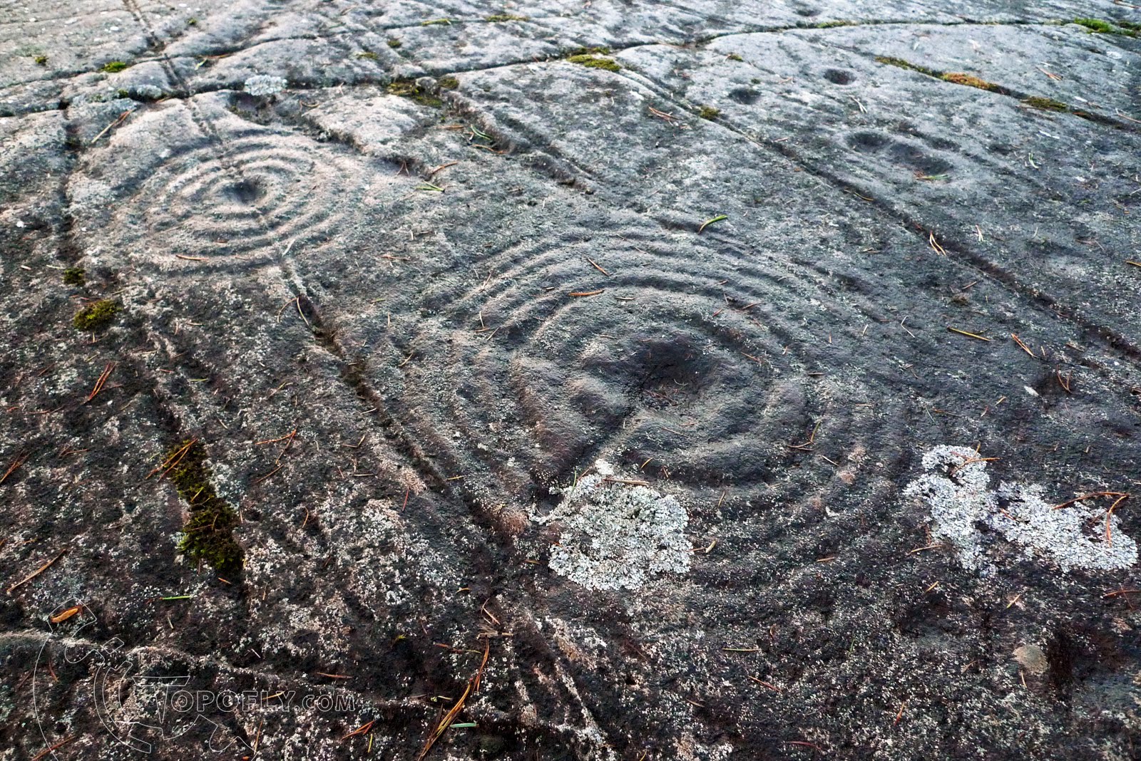
During my summer visit to the Galician coast in northern Spain I was intrigued to visit one of the many sites of Cup and Ring rock art which look so familiar from prehistoric sites in Scotland. With the aid of a map, a patient interpreter (thanks Nuria) a long bus journey and a friendly taxi driver we arrived at Laxe das Rodas. The cravings here are particularly well executed, both neat and still deeply inscribed in parts although the rock surface is well exposed and appears to have weathered considerably. The interpretive panel attributes the petroglyphs to the late Bronze Age / early Iron Age. Considering that long-distance travel at that time was likely made along the coast in vessels just a bit more substantial than ocean-going canoes (although surprising sophisticated in examples such as the Dover Boat) it is remarkable to see such striking similarities in contemporary rock art at home, over 900 miles away.

For a point of visual comparison I have included photographs of Achnabreck rock carvings in Argyll, Scotland alongside shots of Laxe das Rodas in Galicia, Spain. Perhaps the most obvious distinction is the weather - unsurprisingly the wet photographs where taken in Scotland, the shots in baking sunshine taken in Spain!

One of the most distinct cup and ring carvings, Laxe das Rodas, Calicia, Spain.
A similar design at Achnabreck, near Kilmartin Glen, Argyll, Scotland.
Another apparent similarity is the choice of location for the carving sites which both command views across the entrances between the coast and inland areas. While Laxe das Rodas is positioned above the entrance to La Ría de Muros y Noya, and is in direct line of site with Castro de Baroña (see previous post), Achnabreck overlooks the modern day Lochgilphead, one of the approaches to Kilmartin Glen, which had much sacred importance in prehistory.

A complex spiral and dot pattern at Laxe das Rodas.
The carvings at Achnabreck include rare "horned spiral" motifs
Of the distinguishing features of the Galician rock art I was interested to see that representational artwork seemed a lot more common, certainly compared to the examples of rock art in Argyll where there are only a few representations of axe heads. There are very small and obscure marks on the Laxe das Rodas spiral above which may represent human figures and more extravagant representations of deer appear at nearby rock art sites. Despite the distingushing characteristics of the two sites, to the untrained eye the similarities in symbology and style are astounding bearing in mind the distances involved.


Note that Google Maps doesn't have the option to provide directions for canoe. Instead this map shows a suggested route between the two sites over land, one which was probably most impractical during the Bronze Age.

Friday, 5 October 2012

What I Did On My Holidays: Kite Photography on the Galician Coast

During September I spent a week on break visiting my girlfriend's home town of A Coruña and a little of the surrounding coast of Galicia in northern Spain. Between experiencing the excellent local hospitality we got out and about, myself with kite in hand, for a glimpse of Galicia's history from above.

Figures walking across the sandy land-bridge to Castro de Baroña.

Our first port of call was the fantastic Iron-Age fortified settlement of Castro de Baroña, one of many hill-fort sites in the area but one which is particularly striking for it's location on a narrow rock peninsular. This semi-island setting is one which is familiar - the strategy of using water as a natural defense is found in many Scottish Crannogs and Brochs as well sites such as St Ninian's Chapel and Dunottar castle.

A vertical shot of the entrance way and first set of houses.
After passing through a narrow entrance way in the imposing defensive walls the visitor arrives at the remains of a series of roundhouses, a style of dwelling also typical in pre-Roman Britian. From above the similarities to a British hill-fort are startlingly apparent.

These ruins have been excavated and later consolidated using concrete, a process which is clearly ongoing as a large section of the outer wall (visible above) and several roundhouses had been recently worked on. Such extensive consolidation is an unfortunate necessity at a site with such high visitor numbers. Our taxi driver explained that although the site is very popular there is little public interpretation (none at all on site) and as such visitors show little respect for the remains without knowing their age and importance.

Recently consolidated roundhouses appear lighter than the others in this view.
Towards evening a haze descended on the coast softening the sunlight which illuminates the general view below, looking towards the opposing peninsular visible in the background. These two outcrops of land overlook the entrance to La Ría de Muros y Noya, a channel of water which is likely to have acted as a transportation link between the interior and the coast.

Both sides of the entrance are marked with ancient remains - Castro de Baroña on the south side and a petroglyph rock carving site, in direct line-of-sight, on the north. Later on we visited the carvings, another clear connection to rock art sites back home, but this will follow in another blog post!

Evening light on the Castro looking across the entrance of the Ría.
Back in A Coruña we visited the iconic Torre de Hércules, a Roman lighthouse restored in the 18th Century. It is the oldest Roman lighthouse to remain in use today and obtained UNESCO World Heritage Site status in 2009.

Torre de Hércules and surrounding coast.
This kite aerial photograph was taken on one of two trips out to the site, on the second attempt high winds hampered kite flying so we climbed the 242 steps to emerge on a very blustery balcony near the top. The remains of foundations from previous incarnations of the tower have been excavated and preserved for viewing under the modern covering built around the base. A fantastic, if tiring, visitor experience!

The star shaped outline of Castillo de San Antón.
Coruña's Castillo de San Antón is another example of sea bound defense which is visually interesting from above. The castle was at one point an island, later linked to the city via a short causeway.

Looking back along the coast from our return flight.
Our flight home offered this fantastic view of the city of Coruña which occupies the narrow peninsula visible just right of center. The strategic advantage of occupying coastal outcrops defending the routes inland seems to be demonstrated all along this coastal region. I found it intriguing to follow these patterns, with repeating themes going back into prehistory and spanning at least a thousand miles back to the Scottish monuments with which I'm familiar.

Although blessed with good weather during our stay we had not nearly enough time to explorer Galicia as much as I would have liked. I look forward to the next visit!

Wednesday, 3 October 2012

Thoughts from High Altitude

Reading an interview with the Scottish aerial photographer and artist Patricia Macdonald, given in 2004, I am reminded of a flight which I took a few weeks ago on a particularly fine morning from London Stanstead to Santiago de Compostela in Galicia, Spain. I always relish the opportunity for air travel - nibbling overpriced airline food in the relative comfort of an airline cabin while staring out into the the strange no-man's land of high altitude airspace is a surreal experience. As the landscape slowly evolves from the familiar to the other-worldly I find it easy to be lulled into a state of reflection.

The Cantabrian Mountains, Northern Spain.
The view from the airplane window offers a sense of scale and context which is difficult to grasp from the ground. Passing through layers of cloud, which normally appear as if flattened to the inside of a sphere, reveals their depth and complexity. The vast interaction of land, sea, sun and sky can become visually abstracted, an almost alien world yet one which is in some ways more truthful than a ground level perspective. These paradoxical characteristics of the aerial view are referred to by Macdonald as a "...comprehensiveness [combined] with relative unfamiliarity and a related tendency towards abstraction" (Macdonald, 2004).

Passing over the seaport of Lorient in Brittany, France.
While crossing the bay of Biscay only the occasional ship, barely visible, gives the remotest suggestion of scale. The Atlantic swell mimics the patterns of smaller waves, or of ripples, a fractal effect which tricks the eye. I am reminded of this ever changing, almost hypnotic performance by Macdonalds description:
"The aerial viewpoint allows a strange combination of 'gazing' and 'glancing' (two 'modes' of photographic seeing which are normally distinct), which can lead to what feels like a kind of enhanced awareness" (Macdonald, 2004).
Reference:
(interview by) Stevenson, S., 2004. Patricia Macdonald in conversation with Sara Stevenson. History of Photography, 28, pp. 43-56.

Friday, 10 August 2012

Upcoming Exhibition of MSc Work

After a year of exploration and experimentation the outcome of my MSc work will exhibit at the Dundee Masters Show from the 17th to the 26th of August. Details of the show are available via the university website here.

My projects have been designed to expand upon a central question of what low altitude aerial photography can bring the representation and visualization of heritage. The suitability of low aerial photographs for the purposes of structure from motion photogrammetry has been key to my investigations and 3D meshes generated in this way are the foundation of my visualization work.


This snowy looking mesh of Jarlshof consists of 1.6 million vertices and was pieced together from thousands of photographs taken from an 8m pole, in order to reach every niche and corner of the monument site. This is compared with a kite aerial photograph taken at a later date with special permission from the nearby air traffic control tower at Sumburgh airport.

The 3D model was created from Photosynth point clouds which were meshed and aligned using Meshlab. Although the very low level pole photographs were ideal for the purpose of generating the detailed mesh, the broad coverage of the kite's views were far better suited for texturing which was done by projecting photographs onto the surface in Mudbox.


This workflow allowed me to capture the site at particular times of day and recreate the environment in 3D, with the potential to manipulate the atmosphere for greater narrative effect. This kind of recreated environment is well suited to demonstrate how reconstructions of lost structures fit into the site as the visitor would find it today. These ideas are the basis of my short film about Jarlshof and it's 4,000 year story, which will be on display during the masters show week.

I was lucky enough to also be involved in research project led by Alice watterson to visualize Skara Brae, a neolithic village on the Orkney Islands. This presented an opportunity to explore these techniques further, looking at the incorporation of live action footage as well as how the same approach can be applied on a macro scale with artifacts.


This still frame shows an example of scratch art from Skara Brae which has been reconstructed using photogrammetry, bringing it into an environment where elements such as the firelight can be added. The finished shot, incorporating pigment added by Aaron Watson, will form part of a collaborative film which will hopes to be aired on site.

During my MSc studies I have raised a lot of question in the course of answering a few. I look forward greeting any and all interested parties at the masters show, which marks the end of a chapter, but not the end of the journey!

Saturday, 21 July 2012

Jarlshof Reconstruction Sequence Draft 2.1

This is the sequence which I have been using as a basis for the reconstructed elements in 3D, as well as the informing the low aerial angles which I will use for each stage of the short Jarlshof film. I've been lucky to have Alice Watterson contributing to the archaeological reconstruction for the Norse and later phases, allowing me to focus on the environment and atmosphere using the captured photography and photogrammetry, as well as reconstructing the prehistoric phases of habitation.

These early phases will be reconstructed where possible using aerial photography from other better surviving sites such as nearby Mousa Broch, or contemporary reconstructions such as the wheelhouse at nearby Scatness.

Friday, 6 July 2012

Completing the Jarlshof Photogrammetry Mesh

The mesh below was created from ten sections of photogrammetry taken with a camera on an eight meter pole in December last year. Although this mesh covers most of the site I was keen to aim for more complete coverage so one of the jobs for my return visit in April was to capture the remaining material needed to fill the holes.


I took a printout of the above plan view of the mesh back on site so that I could target the areas of sparse coverage, highlighted in red. In addition I wanted to extend the mesh into all four corners of the boundary fence and add some low level detail to the enclosed broch wheelhouse structures.


The coloured sections in this images represent the supplementary data captured in April, while the original data is shaded in grey. Over that last few days I've been processing and aligning these sections using the Iterative Closest Point alignment tool in Meshlab. I'm quite happy with the consistency of coverage at this point and the next stage is to stitch these sections together into one seamless mesh.

The original data consisted of 2.8 million vertices and I am adding an additional 0.9 million to that so am expecting the re-meshing process to require even more patience than usual. Once I have a single master mesh this can be broken down into more manageable chunks for texturing and rendering.

St Andrews Kite Aerial Photograph Published in Aurora Magazine


My photograph of St Andrews Cathedral appeared in 'The Big Picture' feature in Aurora, the quarterly customer magazine for Highlands and Islands Airports. This dramatic ruined site makes for a particularly striking low aerial view, although I had to manoeuvre carefully around those lighting conductors!