


The World Wide KAP Community Project was the idea of Argentinian kite aerial photographer Ramiro Priegue who, in 2009, sent the WWCP banner on its journey around the world. Each participant takes some kite photographs featuring the banner, signs it and passes it on. You can plot the banners intrepid journey using the map and gallery at: wwkp.kiteaerialphoto.org. I was lucky enough to be one of the KAPers to take care of the banner as it passed through Scotland this year.
This first kite aerial photograph with the banner was taken above Law Hill, which dominates my hometown of Dundee. Incidentally, the two red and blue striped tower blocks on the right hand side of the frame were demolished just 11 days after this shot was taken (video here). This makes the photograph already out of date but all the more unrepeatable! A rectangular Iron Age hill fort once spanned the entire summit of the hill and the ramparts are still visible to the left of frame (site record here), although the near end has been destroyed during the building of the war memorial and viewing platform.
Another favorite local KAP spot which I felt was a must for the banner was Broughty Ferry Castle. Seen here in evening light with Broughty Beach and the mouth of the Tay Estuary behind, the castle's complex shape makes it an interesting subject from low altitude.
Compared to the blustery Law Hill, the promontory at Broughty Castle offered clean winds with an chance to experiment with camera angles a little more. A wide angle lens makes the most of the converging vertical lines in this shot of the castle entrance.
The project aims to bring KAPers together as a community and one of the ways it does this is by providing a good excuse to meet up in order to pass the banner on. I collected the banner from James Gentles at Cairnpapple, a neolithic ritual complex in Westlothian, where we were joined by fellow KAPers Simon Harbord, Sue Storey, John and Cade Wells (and trainee Tom), all of whom can be found listed on the West Lothian Archaeology Group pages here.
James took this shot of all of us with the banner using a remote control rig. This was the first time I had visited Cairpapple, which has special significance both archaeologically and as a focus point for KAP in the Westlothian area. I was last to arrive at the meeting and, as I approached the site, snapped this view with the banner visible and all the kites already in the air.
The banner is always on the move and with it being nearly time for me to pass it on to the next participant, Robert Insall, I found a spot to add my logo. The project has generated a fantastic collection of stories which will hopefully continue to accumulate for many more years as the banner wings its way across the globe.
You can see the current location of the banner along with past and future participants at: wwkp.kiteaerialphoto.org
 |
| The Law Hill, Monument and city of Dundee with the WWKP banner. |
 |
| Passing between KAPers, the banner has already circumnavigated the globe. |
 |
| Broughty Ferry Castle with the WWKP banner, kite aerial photograph. |
 |
| A wide angle near-vertical shot of the castle and banner. |
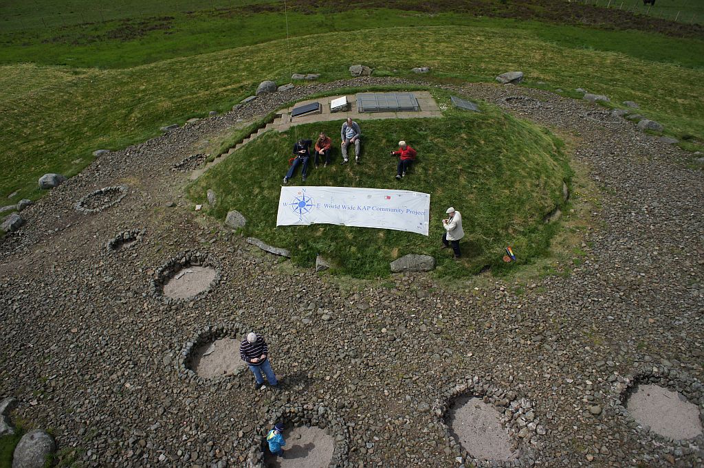 |
| The handover at Cairnpapple, kite aerial photograph by James Gentles © 2013. |
 |
| The group of KAPers flying with the WWKP banner at Cairnpapple. |
 |
| Joining the many distinguished and multinational signatures on the banner. |


