As part of a collaborative effort to visualise Skara Brae I captured a series of kite aerial photographs as a starting point for a 3D reconstruction. Ultimately I aim to create an animated sequence showing an aerial approach to Skara Brae. This will be combined with live action footage, reconstruction and interpretations by both Aaron Watson and Alice Watterson to form a short film which aims to show the multi faceted nature of the site.
Skara Brae is set in a striking location, poised above the sweeping Bay of Skaill. Erosion from the sea here has contributed to both the sites discovery and partial collapse. From above the modern paving becomes particularly obvious, a necessity caused by swelling visitor numbers. One of the modern additions which aim to protect the site is the roofing on house 7, first constructed in glass, and then the turf which is visible here. The need for protection against the erosion caused by visitor numbers at Skara Brae means that many areas are out of access to the public, one of the issues which our visualisation hopes to address.
The house in the foreground here is quite different to the others architecturally (although each of the houses are distinct in some way) and is set aside form the rest of the village leading to speculation that it was used differently, perhaps as a workshop. It's symmetry and strong outline makes it particularly attractive from the air.
As well as the low altitude aerial photography I also spent some time photographing the detailed scratch art which adorns many stones in the houses and passageways. Perhaps the strongest example is this "bed" slab in house 7 which I focused on capturing with a 3D interpretation in mind.
Both these inaccessible details and aerial perspectives represent different kinds of privileged views, normally out of reach from the visitor. The outcome of our visualisation work has the potential not only to give an experiential glimpse of these vantage points but also to contextualise these distinct aspects of the site within each other. I hope to be able to present some more work from this exciting project soon!
Saturday, 30 June 2012
Kite Photography in Orkney
I recently had the pleasure of being involved in a collaborative research project working with Aaron Watson and Alice Watterson who organised the project. Focused on Skara Brae, a neolithic village in the Orkney Islands, the project has taken the form of a collaborative mixed media film, which I will post more about soon. In the mean time here are some kite aerial photographs taken during our week of field work around the fantastic ancient monuments of Orkney.
The Ring of Brodgar is a neolithic stone circle and henge roughly contemporary with Skara Brae. It's vast diameter (around 100m) made it particularly difficult to photograph but after a few missed dinners waiting for the illusive evening sunlight we captured this image looking along the narrow spit of land towards the Ness of Brodgar and the Stones of Steness (pictured below).
Stenness is a smaller standing stone circle and henge which includes a central hearth. The path which runs through the picture leads to Barnhouse, a neolithic settlement just visible in the background.
Jumping forward a few thousand years to the Iron Age, a visit to the Broch of Gurness was of interest to my own project which is largely focused on the brochs. John Hamilton speculated that the missing doorway in the broch and courtyard at Jarlshof may have been aligned to create a straight passage way, similar to the entrance here at Gurness, visible on the right.
![]() |
| The Ring of Brodgar, Kite Aerial Photograph. |
The Ring of Brodgar is a neolithic stone circle and henge roughly contemporary with Skara Brae. It's vast diameter (around 100m) made it particularly difficult to photograph but after a few missed dinners waiting for the illusive evening sunlight we captured this image looking along the narrow spit of land towards the Ness of Brodgar and the Stones of Steness (pictured below).
![]() |
| The Stones of Stenness, Kite Aerial Photograph. |
![]() |
| Broch of Gurness, Kite Aerial Photograph. |
Wednesday, 16 May 2012
Photogrammetry Test on a Known Surface
This test was designed to evaluate the procedure which I am using for meshing photogrammetry using Microsoft Photosynth and Meshlab, in a way which will be useful for to me when considering software solutions and recording images for photogrammetry. In particular I was interested to see the relationship between the
spacing of pixels (Ground Sampling Distance) and
the distribution of point cloud data generated in Photosynth.
I chose the stone slab below as a subject and photographed it using an adjustable pole in order to control the distance between the camera and the surface.
Known Constants-
The slab top measured 1.2m x 0.6m (with a negligible error of ±1mm) giving it a surface area of 0.72m² and a total distance around it's edges of 3.6m. These values were used to calculate pixel sampling distance and point density per area.
The camera used was a Panasonic DMC-LX3 and for the duration of the shoot images were captured at 1/2000 of a second at f/5, 80 ISO and 5.1mm focal length. 15 frames were taken for each sample with a horizontal movement while the camera was positioned perpendicular to the ground.
Know Variables-
Three sample sequences were taken from three different heights, named Low, Mid and High. As the pole was handheld, values for these heights were derived afterwards using Autodesk 123D Catch, although until tested further these values may also include an unknown factor of error.
Unknown Constants-
The accuracy of the mesh was later measured assuming a perfect surface plane as flaws in the geometry of the slab were taken to be irrelevantly small compared to the error being measured. The suitability of colour features on the surface, in this case the grain of the stone, are likely to effect the effectiveness of the photogrammetry considerably.
Unknown Variables-
Motion blur and focus blur within the camera were reduced by careful handling and also by shooting with a fast shutter speed and small aperture. Differences in the distribution of the camera positions for each sample may also effect the results.
The Procedure-
To calculate the ground sampling distance one sample image was selected from each set where the test surface was centred within the frame. The total pixel distance around the edges of the surface was then measured and compared to the known real world distance of 3.6m.
Each of the three sequences of 15 photographs were uploaded to Photosynth and the resulting point clouds were processed in Meshlab. The points associated with the test surface were separated by eye based on their position and colour values. This distinction was quite clear as the test surface was raised for the ground and very little data was captured relating to the sides of the slab.
These original points were then reduced and meshed using the following procedure-
- Compute normals for point sets [Number of neigbors: 10]
- Surface Reconstrution: Poisson [Octree Depth: 14]
- Subdivision Surfaces: LS3 Loop [Iterations: 3]
- Subdivision Surfaces: Catmull-Clark
- Vertex Attribute Transfer: [From point set: Color, Normal, Geometry]
- Remove Duplicate Vertex
The resulting meshed vertices retain the position of original points although some points which fall outside the average surface are ignored, hence the reduced figure of Selected Points shown below. In order to form a useful comparison with the ground sampling distance an average point distribution distance was derived form the point density (assuming for this purpose that the points formed a matrix). In each sample this figure was found to be roughly 30 times the ground sampling distance, suggesting that for every 30 pixels distance you would expect to find, on average, one point sampled from Photosynth.

To assess the accuracy of the meshed surfaces the three samples were aligned by eye to each other and to an estimated true surface (shown below in red) in order to establish a rough vertical scale. A ramp shader was then applied to the surfaces and a histogram derived from each sample showing the vertical distribution of points. We can see that the Low sample has a fairly defined spike as would be expected with a factor of error in the range of around ±10mm. This error broadens as the camera gets further away with the High sample including a factor of error up to ±25mm and an indistinct spike associated with the true surface.
In Conclusion-
The results suggest a linear relationship between ground sampling distance and the distance between points derived from photogrammetry. A factor of error apears to be similarly associated with ground sampling distance. Further testing is required to establish how varying other factors such as the surface and the software used would effect the density and accuracy of points. These values may be improved in other photogrammetry solutions which, unlike Photosynth, are specifically designed for surface meshing. One source of error which stood out during this test occurred around the edge of the surface where the overlapping planes appeared to create "sliding" rouge points.
While photographing using a pole served to simulate the constraints of kite or pole aerial photography for photogrammetry, future tests may be controlled better using a vertical subject photographed from the ground.
I chose the stone slab below as a subject and photographed it using an adjustable pole in order to control the distance between the camera and the surface.
Known Constants-
The slab top measured 1.2m x 0.6m (with a negligible error of ±1mm) giving it a surface area of 0.72m² and a total distance around it's edges of 3.6m. These values were used to calculate pixel sampling distance and point density per area.
The camera used was a Panasonic DMC-LX3 and for the duration of the shoot images were captured at 1/2000 of a second at f/5, 80 ISO and 5.1mm focal length. 15 frames were taken for each sample with a horizontal movement while the camera was positioned perpendicular to the ground.
Know Variables-
Three sample sequences were taken from three different heights, named Low, Mid and High. As the pole was handheld, values for these heights were derived afterwards using Autodesk 123D Catch, although until tested further these values may also include an unknown factor of error.
Unknown Constants-
The accuracy of the mesh was later measured assuming a perfect surface plane as flaws in the geometry of the slab were taken to be irrelevantly small compared to the error being measured. The suitability of colour features on the surface, in this case the grain of the stone, are likely to effect the effectiveness of the photogrammetry considerably.
Unknown Variables-
Motion blur and focus blur within the camera were reduced by careful handling and also by shooting with a fast shutter speed and small aperture. Differences in the distribution of the camera positions for each sample may also effect the results.
The Procedure-
To calculate the ground sampling distance one sample image was selected from each set where the test surface was centred within the frame. The total pixel distance around the edges of the surface was then measured and compared to the known real world distance of 3.6m.
Each of the three sequences of 15 photographs were uploaded to Photosynth and the resulting point clouds were processed in Meshlab. The points associated with the test surface were separated by eye based on their position and colour values. This distinction was quite clear as the test surface was raised for the ground and very little data was captured relating to the sides of the slab.
These original points were then reduced and meshed using the following procedure-
- Compute normals for point sets [Number of neigbors: 10]
- Surface Reconstrution: Poisson [Octree Depth: 14]
- Subdivision Surfaces: LS3 Loop [Iterations: 3]
- Subdivision Surfaces: Catmull-Clark
- Vertex Attribute Transfer: [From point set: Color, Normal, Geometry]
- Remove Duplicate Vertex
The resulting meshed vertices retain the position of original points although some points which fall outside the average surface are ignored, hence the reduced figure of Selected Points shown below. In order to form a useful comparison with the ground sampling distance an average point distribution distance was derived form the point density (assuming for this purpose that the points formed a matrix). In each sample this figure was found to be roughly 30 times the ground sampling distance, suggesting that for every 30 pixels distance you would expect to find, on average, one point sampled from Photosynth.

To assess the accuracy of the meshed surfaces the three samples were aligned by eye to each other and to an estimated true surface (shown below in red) in order to establish a rough vertical scale. A ramp shader was then applied to the surfaces and a histogram derived from each sample showing the vertical distribution of points. We can see that the Low sample has a fairly defined spike as would be expected with a factor of error in the range of around ±10mm. This error broadens as the camera gets further away with the High sample including a factor of error up to ±25mm and an indistinct spike associated with the true surface.
In Conclusion-
The results suggest a linear relationship between ground sampling distance and the distance between points derived from photogrammetry. A factor of error apears to be similarly associated with ground sampling distance. Further testing is required to establish how varying other factors such as the surface and the software used would effect the density and accuracy of points. These values may be improved in other photogrammetry solutions which, unlike Photosynth, are specifically designed for surface meshing. One source of error which stood out during this test occurred around the edge of the surface where the overlapping planes appeared to create "sliding" rouge points.
While photographing using a pole served to simulate the constraints of kite or pole aerial photography for photogrammetry, future tests may be controlled better using a vertical subject photographed from the ground.
Tuesday, 24 April 2012
Jarlshof: Kite Aerial Photography Within a Controlled Air Traffic Zone
The prehistoric settlement site of Jarlshof is situated just 350 meters from the runway at Sumburgh, the main airport for the Shetland Islands. The site has a complex 4,500 year chronology which best understood from above where the different eras of settlement can be distinguished. For these reasons I chose the site as a main case study for my experimentation, aware that it's position well within a controlled air traffic zone would mean working closely with the demands of Air Traffic Control if permission for my planned kite aerial photography was to be made possible.
The photograph and map above show the proximity of Jarlshof to Sumburgh Airport, in particular the approach to runway 33 which lies a few hundred meters from the site.
In the months before my field trip I was put in touch with the senior air traffic controller at Sumburgh. After establishing the details of the location, the height I would be flying at and the periods I would be flying for, permission was granted at the discretion of the air traffic controller on duty at the time, with the provision that I would be able to land all of my equipment on request if necessary. On arriving in Shetland I was shown the air traffic control tower which is directly across the bay overlooking Jarlshof. It was explained that the on-duty controller is always sat beside an assistant whom I would speak to in the first instance to request permission to fly.
Left: Visiting the air traffic control tower. Jarlshof is visible across the bay in the background
Right: As well regular fixed wing aircraft Sumburgh Airport is frequented by helicopter traffic.
Once the procedures had been established I had a five day window for kite aerial photography with each session dependant on weather and on the demands of air traffic. All told I requested to fly five times, all of them for one hour apart from one sunset session which lasted an hour and a half. Sometimes I was able to fly straight away while on other occasions I had to wait for a quieter period, although the longest I had to wait was an hour. On a couple of occasions I was asked to bring my my equipment down while incoming planes and helicopters passed within close proximity. Where flight paths were far enough away to not be an issue both the pilot and myself would be notified of each others activities and we would both continue. On each occasion I would call to confirm when I was done and my equipment was back on the ground.
Jarlshof is situated on a small outcrop near a sandy bay which would have been used a harbour throughout it's history. Sumburgh Airport is visible just beyond the beach in this kite aerial photograph.
Once again the changeable Shetland weather provided the opportunity for photographs in different lighting conditions, the harsh sunlight above being perhaps the least useful. In bright but overcast conditions I was able to capture some material more suitable for photogrammetry to supplement my previous work with pole aerial photography towards a 3D mesh of the site.
Iron Age broch and wheelhouse structures which lie beneath the 16th Century laird's house.
The ambient light created by overcast weather also provided the best conditions to photograph the broch remains in their entirety, a view which can only be obtained directly above the west corner of the ruined laird's house wall. As usual conditions were most illustrative towards sunset when a low light angle picked up the subtle topography of the site.
Left: Sumburgh Head, the southerly limit of Shetland lies just along the coast from Jarlshof.
Right: The kite and camera rig in action during patchy weather.
Below: In this general view the low light helps to distinguish the different layers of the site.
Low altitude aerial perspectives can provide a sense of depth and context which is often hard to achieve from manned aircraft. These unique shots are part of a wealth of material I was able to capture thanks to favorable weather and the generous assistance of the team at Sumburgh ATC, in particular Alan Smith who arranged provision for my visit. As well as making some very satisfying stills I hope to map some of these sequences onto my 3D representation of the site which in turn will be used as a basis for an interpretative reconstruction of the phases of habitation at Jarlshof.
Further thanks are due to James Gentles and Dave Mitchell who were able to advise based on past experience of KAP within controlled airspace.
In the months before my field trip I was put in touch with the senior air traffic controller at Sumburgh. After establishing the details of the location, the height I would be flying at and the periods I would be flying for, permission was granted at the discretion of the air traffic controller on duty at the time, with the provision that I would be able to land all of my equipment on request if necessary. On arriving in Shetland I was shown the air traffic control tower which is directly across the bay overlooking Jarlshof. It was explained that the on-duty controller is always sat beside an assistant whom I would speak to in the first instance to request permission to fly.
Left: Visiting the air traffic control tower. Jarlshof is visible across the bay in the background
Right: As well regular fixed wing aircraft Sumburgh Airport is frequented by helicopter traffic.
Once the procedures had been established I had a five day window for kite aerial photography with each session dependant on weather and on the demands of air traffic. All told I requested to fly five times, all of them for one hour apart from one sunset session which lasted an hour and a half. Sometimes I was able to fly straight away while on other occasions I had to wait for a quieter period, although the longest I had to wait was an hour. On a couple of occasions I was asked to bring my my equipment down while incoming planes and helicopters passed within close proximity. Where flight paths were far enough away to not be an issue both the pilot and myself would be notified of each others activities and we would both continue. On each occasion I would call to confirm when I was done and my equipment was back on the ground.
Jarlshof is situated on a small outcrop near a sandy bay which would have been used a harbour throughout it's history. Sumburgh Airport is visible just beyond the beach in this kite aerial photograph.
Once again the changeable Shetland weather provided the opportunity for photographs in different lighting conditions, the harsh sunlight above being perhaps the least useful. In bright but overcast conditions I was able to capture some material more suitable for photogrammetry to supplement my previous work with pole aerial photography towards a 3D mesh of the site.
Iron Age broch and wheelhouse structures which lie beneath the 16th Century laird's house.
The ambient light created by overcast weather also provided the best conditions to photograph the broch remains in their entirety, a view which can only be obtained directly above the west corner of the ruined laird's house wall. As usual conditions were most illustrative towards sunset when a low light angle picked up the subtle topography of the site.
Left: Sumburgh Head, the southerly limit of Shetland lies just along the coast from Jarlshof.
Right: The kite and camera rig in action during patchy weather.
Below: In this general view the low light helps to distinguish the different layers of the site.
Low altitude aerial perspectives can provide a sense of depth and context which is often hard to achieve from manned aircraft. These unique shots are part of a wealth of material I was able to capture thanks to favorable weather and the generous assistance of the team at Sumburgh ATC, in particular Alan Smith who arranged provision for my visit. As well as making some very satisfying stills I hope to map some of these sequences onto my 3D representation of the site which in turn will be used as a basis for an interpretative reconstruction of the phases of habitation at Jarlshof.
Further thanks are due to James Gentles and Dave Mitchell who were able to advise based on past experience of KAP within controlled airspace.
Sunday, 22 April 2012
Mousa Broch by Charter Boat and Kite
Out of over 500 Broch sites in Scotland Mousa Broch is the only surviver to remain almost at it's complete height. It stands 13m tall on the small uninhabited island of Mousa a short distance from the Shetland South Mainland. During the summer season a daily boat service runs to the island, operated by the ever helpful Jamieson family for the last 40 years. Unfortunately this year of all years the business changed ownership leaving my access to the island literary high and dry during my week long field trip at the start of April.
Left: The Mousa Ferry as I found it on arrival to Shetland. Notice that it is not in the water.
Right: Mousa island as seen from the South Mainland. The Broch is visible to the right hand side.
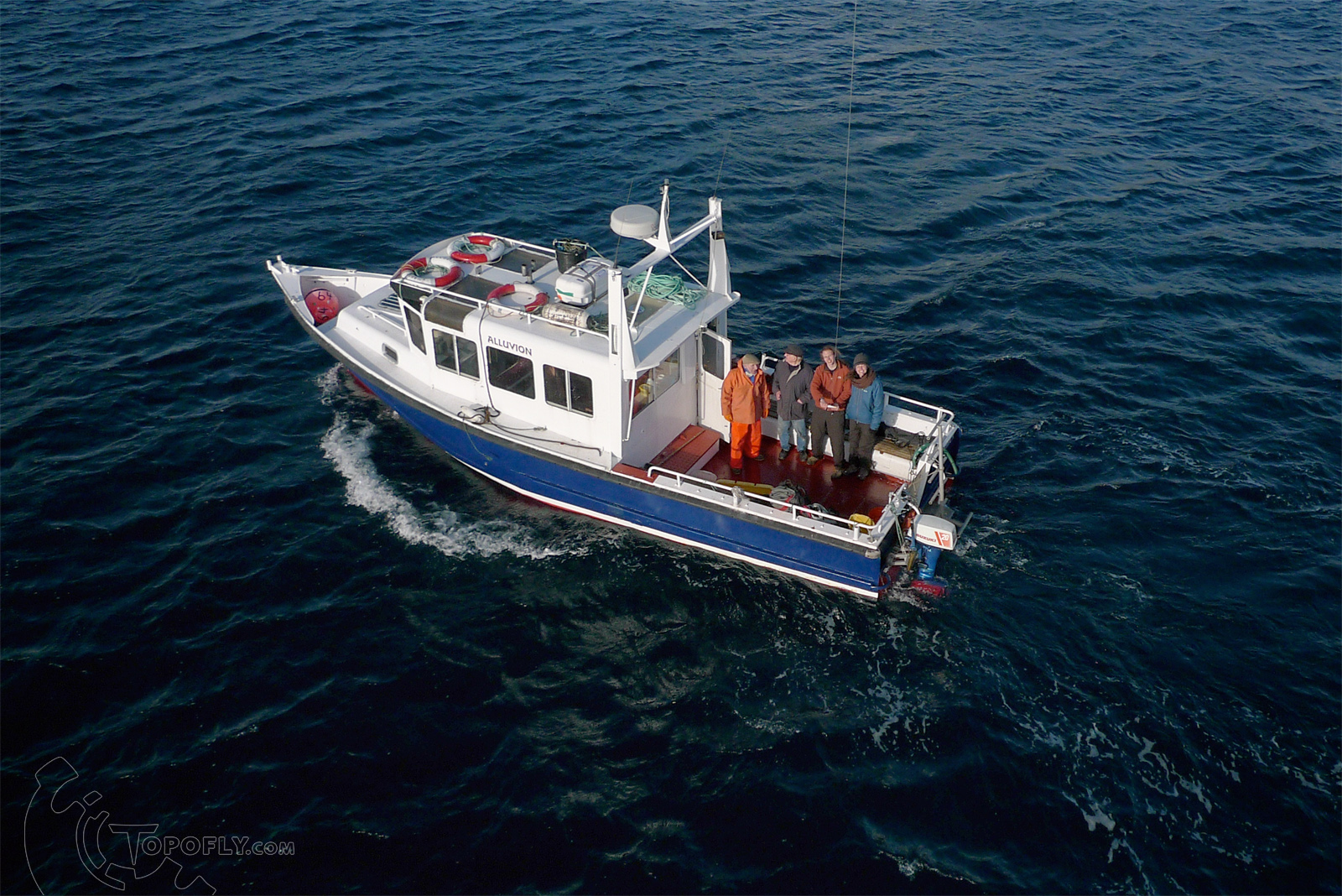
After making enquiries locally I contacted Shetland Sea Charters who operate the MV Alluvion out of Lerwick to arrange provision for a day trip to the island. Choosing a day when the weather was bright, albeit of the usual 'changeable' Shetland character, we motored out of Cunningsburgh and, rather than heading for the pier on Mousa, we went straight to the outcrop where the Broch stands to try some kite photography from the water.
Left: Fine weather conditions as we approached Mousa Island onboard the MV Alluvion.
Right: The MV Alluvion and crew as seen from the kite. Launching and landing my equipment on that stern deck was something of a challenge, but luckily help was on hand.
With a great deal of patience and skill from the skipper and crew we positioned the boat just beyond the rocky shore to shoot these photographs looking down on the Broch within it's island context.
Rig and furrow earthworks are visible running across the land behind Mousa Broch along with later wall and building structures. The rocky outcrop is typical for a Broch setting.
We then landed on the island to take more kite aerial photographs from the landward side, including some material suitable for photogrammetry. As the weather fluctuated between periods of sunshine, cloud and snow showers I was able to take photographs in different lighting conditions all around the broch exterior and interior.
On close inspection a courtyard wall is visible as a line of stones under the grass on the landward side of the broch. There are other features which suggest that a larger settlement extended beyond the Broch itself although the site has never been excavated.
As a particularly heavy snow shower set in we made haste back onboard the MV Alluvion, which had not been idle judging by the crate of fish on deck, and headed back again to the seaward side of the broch for some final kite shots.
A dusting of snow has remained un-melted in the shadows of this image naturally relieving the contrast. The site is particularly pleasing from this angle where the relationship between the monument and the surrounding land is very clear. The paths which radiate from the broch have probably been created by a combination of tourists and sheep taking shelter around the Broch site. This relatively untouched land may give a feeling for how it may have looked when the broch was inhabited and the shaping forces would have been restricted to manual farming and the movements of people and animals.
Some very satisfying results from a sucessfull day's flying and sailing!
Left: The Mousa Ferry as I found it on arrival to Shetland. Notice that it is not in the water.
Right: Mousa island as seen from the South Mainland. The Broch is visible to the right hand side.
After making enquiries locally I contacted Shetland Sea Charters who operate the MV Alluvion out of Lerwick to arrange provision for a day trip to the island. Choosing a day when the weather was bright, albeit of the usual 'changeable' Shetland character, we motored out of Cunningsburgh and, rather than heading for the pier on Mousa, we went straight to the outcrop where the Broch stands to try some kite photography from the water.
Left: Fine weather conditions as we approached Mousa Island onboard the MV Alluvion.
Right: The MV Alluvion and crew as seen from the kite. Launching and landing my equipment on that stern deck was something of a challenge, but luckily help was on hand.
With a great deal of patience and skill from the skipper and crew we positioned the boat just beyond the rocky shore to shoot these photographs looking down on the Broch within it's island context.
Rig and furrow earthworks are visible running across the land behind Mousa Broch along with later wall and building structures. The rocky outcrop is typical for a Broch setting.
We then landed on the island to take more kite aerial photographs from the landward side, including some material suitable for photogrammetry. As the weather fluctuated between periods of sunshine, cloud and snow showers I was able to take photographs in different lighting conditions all around the broch exterior and interior.
On close inspection a courtyard wall is visible as a line of stones under the grass on the landward side of the broch. There are other features which suggest that a larger settlement extended beyond the Broch itself although the site has never been excavated.
As a particularly heavy snow shower set in we made haste back onboard the MV Alluvion, which had not been idle judging by the crate of fish on deck, and headed back again to the seaward side of the broch for some final kite shots.
A dusting of snow has remained un-melted in the shadows of this image naturally relieving the contrast. The site is particularly pleasing from this angle where the relationship between the monument and the surrounding land is very clear. The paths which radiate from the broch have probably been created by a combination of tourists and sheep taking shelter around the Broch site. This relatively untouched land may give a feeling for how it may have looked when the broch was inhabited and the shaping forces would have been restricted to manual farming and the movements of people and animals.
Some very satisfying results from a sucessfull day's flying and sailing!
Monday, 9 April 2012
Kite Photograph Featured in Aurora Magazine
Recently I was asked to supply a Kite Aerial Photograph for the 'The big picture' feature in Aurora, a free quarterly magazine for Highlands & Islands Airports.
HIA operates eleven airports across Scotland including Dundee and Sumburgh in Shetland, so were interested in featuring photography from these areas. This image chosen for Aurora's spring edition is of St Ninian's Isle, taken during my field visit to Shetland last December.
The magazine is available to view online here.
Saturday, 24 March 2012
Carlungie Souterrain KAP

Carlungie souterrain is one of three of these Iron Age cellars near to Dundee which have served as a bit of a testing ground for my equipment and techniques for low altitude aerial photography and photogrammetry. These images were taken using a kite during mid afternoon sunlight to show up the paved floor.
The smaller snaking passageway would have lead from space where the residents lived to the large cellar space which would have been roofed, creating cool and dry conditions. From above the remains form an interesting sprawling pattern which shows the vast extent of the storage space. The entrance passage in contrast is very narrow and would only have been accessible by crawling.

I will use this sequence to generate a 3D model which I can use to experiment with ways of viewing the site. The RCAHMS site record can be found here.
Subscribe to:
Posts (Atom)